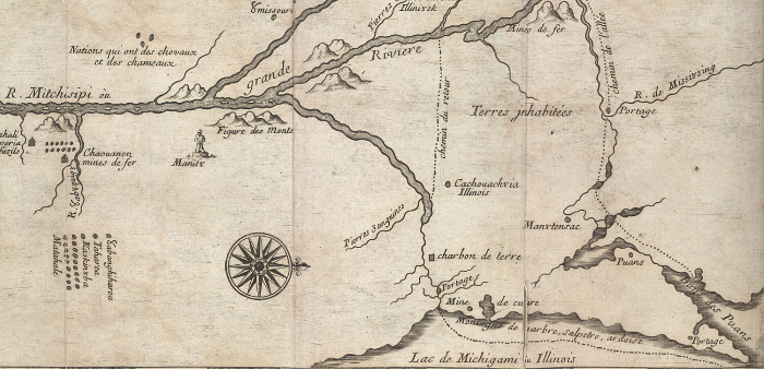
 Map by Marquette and Joliet (detail; full map here)
On May 17, 1673, two French explorers assisted by five mixed-race voyageurs set out from St. Ignace in Quebec Province in a pair of birchbark canoes, traveling down the shores of Lake Michigan to what is now Green Bay. Louis Joliet was a fur trader. Jacques Marquette was a Jesuit priest who spoke six Indian languages. The mission given them by the Governor of French Canada was to discover and map the “Great Western River” (the Mississippi) which, they hoped, would lead to China. Chicago’s myth begins with France, the “Indians” and above all, the Orient.
 Tiffany Mosaics, Marquette Building, Chicago, 1897

From Green Bay, recounts Edward Bilek, the two explorers paddled up the Fox river, made a difficult portage over steep terrain to the Wisconsin and finally reached the Mississippi on June 17. They continued downstream as far as the mouth of the Arkansas, where they were warned of armed and hostile tribes to the south. Realizing by this point that the Mississippi led to Mexico and not to China, they decided to make their way back to Québec and to seek a shorter and easier passage via the Illinois River. Thus it was on their return voyage that they “discovered” what the native inhabitants had long known and had described to them in advance of their “discovery”: the Chicago Portage.
The portage was a large slough located, according to Philip Virling, “between what is now Archer Avenue and Ogden Avenue and extending from about Albany Avenue (3100 West) to Harlem Avenue (7200 West).” It came to be called “Mud Lake.” In the best of times (between freezing winter and parched summer) a canoe or shallow-draft river boat could be hauled from the South Branch of the Chicago River through the thick, leech-infested slough to the clear waters of the Des Plaines River, and from there, to the Illinois. Otherwise, the boat could be carried over a slightly longer dry-land route, crossing the continental divide and joining the Atlantic and Mississippi basins.
Mud Lake was the original switching yard, the place where it all began, Chicago’s raison d’être: a strategic military asset and, above all, a crucial link in the fur trade for the next hundred years. As Bilek writes: “The original portage now became the route over which fox, beaver, muskrat, mink, marten, and deer skins in mackinaw boats, floating rafts, canoes, and batteaux were carried on their way to the fabulous courts of Europe.”
 As early as 1673, Joliet envisioned a canal through the “half a league of prairie” separating the Chicago and Des Plaines rivers. A century and a half later, over the period from 1836 to 1848 (with a major interruption due to the Panic of 1837) the 94-mile long Illinois and Michigan Canal was dug from Chicago’s Bridgeport district to La Salle, Illinois. Seventeen locks and four aqueducts were required to negotiate the 140-foot difference in water level between Lake Michigan and the Illinois River. Although rapidly obsolete due to the construction of railroads from 1848 onward, the I&M Canal transformed the regional geography, opening up a new route for the transport of grain, coal and other heavy materials from the Midwestern hinterland to Chicago and the Eastern Seabord.
At the close of the 19th century, in a scheme to combine intensified barge traffic with a solution to Chicago’s perennial sewage problem, the Sanitary and Ship Canal was constructed alongside the old I&M. The Atchison, Topeka and Santa Fe rail line (today’s BNSF) also clung to the route of the old canal on the way to its terminus, at Corwith Yard near Kedzie Avenue. Later, Interstate 55 took off in parallel to the canal and rail route. A dense industrial and transport corridor now runs from Bridgeport and the Calumet River Basin to the city of Joliet, where Oriental commodities arrive in sealed freight containers from China (via Long Beach and the warehouses of LA’s Inland Empire). Midway airport, once the nation’s busiest, lies just to the north. The planes buzz over the trucks that speed by the trains that leave the barges soldiering through the locks of the canal, carrying thousands of tons of fossil coal to power all that hypermodern motion.
The whole thing, which becomes more intense with each click of the atomic clocks, is considered “heritage” by the cultural establishment. For some relaxation you can hike or bike through the National Heritage Corridor that follows fragments of the I&M through peaceful woodlands and devastated industrial parks, or you can launch a canoe in some of the longer stretches, or take a hokey “just like it was” mule-pulled canal boat tour out by La Salle. Or maybe you should just do a little fishing (catch and release might be better for your health) and above all, catch a nice sunset at the Canal Origins Park on Ashland where it crosses the South Branch of the Chicago River. Best of all, from May to November, at 10 am on the first Saturday of each month, take the free Chicago Portage Tour and hear some excellent local historians spin tales of the place where it all began.
